New Perspectives on American History, 2023 GOP Edition
Here is a recent post seen on the Ex-Birb Site from Kevin Owen McCarthy,[1] onetime Speaker of the House and current Representative[2] in the so-called House of Representatives of the United States Congress. This was posted at 7:06 PM on November 26, 2023:
@SpeakerMcCarthy: Think for one moment. In every single war that America has fought, we [sic] have never asked for land afterward—except for enough to bury the Americans who gave the ultimate sacrifice for freedom.
Think for one moment.
Kevin O. McCarthy was born in Bakersfield. He currently represents the 20th Congressional district in the state of California.
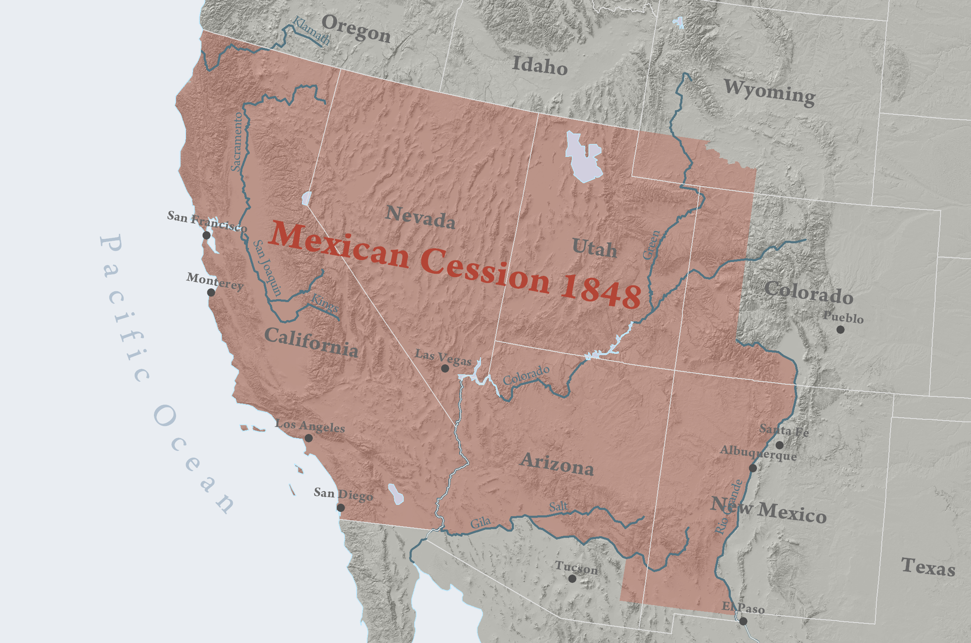
The State of California became part of the internationally-recognized territory of the United States of America in 1848, and then became a U.S. state in 1850, as a result of Article V of the Treaty of Guadalupe Hidalgo.
Article V
The boundary line between the two Republics shall commence in the Gulf of Mexico, three leagues from land, opposite the mouth of the Rio Grande, otherwise called Rio Bravo del Norte, or Opposite the mouth of its deepest branch, if it should have more than one branch emptying directly into the sea; from thence up the middle of that river, following the deepest channel, where it has more than one, to the point where it strikes the southern boundary of New Mexico; thence, westwardly, along the whole southern boundary of New Mexico (which runs north of the town called Paso) to its western termination; thence, northward, along the western line of New Mexico, until it intersects the first branch of the river Gila; (or if it should not intersect any branch of that river, then to the point on the said line nearest to such branch, and thence in a direct line to the same); thence down the middle of the said branch and of the said river, until it empties into the Rio Colorado; thence across the Rio Colorado, following the division line between Upper and Lower California, to the Pacific Ocean.
The southern and western limits of New Mexico, mentioned in the article, are those laid down in the map entitled “Map of the United Mexican States, as organized and defined by various acts of the Congress of said republic, and constructed according to the best authorities. Revised edition. Published at New York, in 1847, by J. Disturnell,” of which map a copy is added to this treaty, bearing the signatures and seals of the undersigned Plenipotentiaries. And, in order to preclude all difficulty in tracing upon the ground the limit separating Upper from Lower California, it is agreed that the said limit shall consist of a straight line drawn from the middle of the Rio Gila, where it unites with the Colorado, to a point on the coast of the Pacific Ocean, distant one marine league due south of the southernmost point of the port of San Diego, according to the plan of said port made in the year 1782 by Don Juan Pantoja, second sailing-master of the Spanish fleet, and published at Madrid in the year 1802, in the atlas to the voyage of the schooners Sutil and Mexicana; of which plan a copy is hereunto added, signed and sealed by the respective Plenipotentiaries.
In order to designate the boundary line with due precision, upon authoritative maps, and to establish upon the ground land-marks which shall show the limits of both republics, as described in the present article, the two Governments shall each appoint a commissioner and a surveyor, who, before the expiration of one year from the date of the exchange of ratifications of this treaty, shall meet at the port of San Diego, and proceed to run and mark the said boundary in its whole course to the mouth of the Rio Bravo del Norte. They shall keep journals and make out plans of their operations; and the result agreed upon by them shall be deemed a part of this treaty, and shall have the same force as if it were inserted therein. The two Governments will amicably agree regarding what may be necessary to these persons, and also as to their respective escorts, should such be necessary.
The boundary line established by this article shall be religiously respected by each of the two republics, and no change shall ever be made therein, except by the express and free consent of both nations, lawfully given by the General Government of each, in conformity with its own constitution.
— Treaty of peace, friendship, limits, and settlement between the United States of America and the United Mexican States concluded at Guadalupe Hidalgo (English version).
The Treaty of Guadalupe Hidalgo was signed and ratified in 1848. In the treaty the United States government demanded the accession of 525,000 square miles of land formerly claimed by the Mexican Republic after invading Mexico, killing about 25,000 Mexicans, and finally conquering and occupying the capital city, in a declared war from 1846-1848.[3]
Mexican-American War
Main article: Mexican-American War
Alta California and Santa Fe de Nuevo México were captured soon after the start of the war and the last resistance there was subdued in January 1847, but Mexico would not accept the loss of territory. Therefore, during 1847, troops from the United States invaded central Mexico and occupied the Mexican capital of Mexico City, but still no Mexican government was willing to ratify the transfer of the northern territories to the U.S. It was uncertain whether any treaty could be reached. There was even an All of Mexico Movement proposing complete annexation of Mexico among Eastern Democrats but opposed by Southerners like John C. Calhoun who wanted the additional territory for their crops but not the large population of central Mexico.
Eventually Nicholas Trist forged the Treaty of Guadalupe Hidalgo, explicitly redefining the border between Mexico and the United States in early 1848 after President Polk had already attempted to recall him from Mexico as a failure. . . .
The Mexican Cession as ordinarily understood (i.e. excluding lands claimed by Texas) amounted to 525,000 square miles (1,400,000 km2), or 14.9% of the total area of the current United States. If the disputed western Texas claims are also included, that amounts to a total of 750,000 square miles (1,900,000 km2). If all of Texas had been seized, since Mexico had not previously acknowledged the loss of any part of Texas, the total area ceded under this treaty comes to 915,000 square miles (2,400,000 km2).
Considering the seizures, including all of Texas, Mexico lost 55% of its pre-1836 territory in the Treaty of Guadalupe Hidalgo.[4] . . .
About 27% of the current American population — including Kevin O. McCarthy, when he is not in Washington, D.C. — lives in states that were partly or entirely transferred to the United States as part of the Mexican Cession. If you think for one moment, you might notice that the reason Kevin McCarthy of Bakersfield, Alta California is a U.S. Congressman and not a Mexican national, is precisely because he was born and grew up and worked and lives on land that the U.S. government, which I have to presume is what he means by America
asked for
in a list of treaty demands at the end of a crushing victory in a years-long war of conquest and occupation. After a moment, you might wonder what the point of these kind of statements, patriotic guff that is just obviously and wildly non-factual, counter-factual, perhaps basically anti-factual in its presentation, could possibly be.
- [1]The Roger H. Sterling Jr. of American politics.↩
- [2][Sic. —R.G.]↩
- [3]In point of fact, a lot of the land that the U.S. government asked for after the war was only claimed by Mexico, but not really settled by Mexican people or controlled by the Mexican government. Other people lived there at the time, in communities of their own — most of them tribal Indians. Article XI of the same treaty actually acknowledges this, when it provides for U.S. security guarantees to Mexico against the other people living in the territory,
Considering that a great part of the territories, which, by the present treaty, are to be comprehended for the future within the limits of the United States, is now occupied by savage tribes [sic], who will hereafter be under the exclusive control of the Government of the United States….
As a result both of the guarantees made in this article, and also the U.S.’s own efforts to control and settle colonies of Americans in the interior of the territory, they spent the next three decades or so repeatedly fighting wars with Indians in the southwest territories they patrolled, taking over control of the land from the defeated nations, and forcing them to migrate to new territories or to settle on reservations.↩ - [4][Table 1.1 Acquisition of the Public Domain 1781–1867 Archived September 29, 2006, at the Wayback Machine. —Wikipedia]↩


